Imatge:WalesGwynedd.png
De Viquipèdia
No hi ha una versió amb una resolució més gran.
WalesGwynedd.png (200 × 225 píxels, mida de l'arxiu: 22 KB, tipus MIME: image/png)
| | Aquest arxiu és una càrrega compartida, extreta del projecte Wikimedia Commons i pot ser usada per altres projectes. Si voleu disposar de més informació sobre el fitxer, podeu visitar la pàgina original |
[edit] Summary
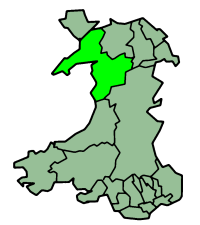
Map of Gwynedd —Walden69 12:16, 11 April 2006 (UTC)
| Description |
English map of Gwynedd (one of the subdivisions of Wales) |
|---|---|
| Source | |
| Date |
of this version : 21 January 2004 |
| Author | |
| Permission (Reusing this image) |
GFDL |
| Other versions | en:Image:WalesGwynedd.png |
Image history on en:
| Date | Author | Edit summary |
| 23:36, 21 January 2004 | en:Morwen (Talk) | 200x225 (22,409 bytes) (one of the en:subdivisions of Wales) |
[edit] Licensing
 |
Permission is granted to copy, distribute and/or modify this document under the terms of the GNU Free Documentation License, Version 1.2 or any later version published by the Free Software Foundation; with no Invariant Sections, no Front-Cover Texts, and no Back-Cover Texts. Subject to disclaimers. Asturianu | Български | Català | Deutsch | English | Español | Français | Gaeilge | Italiano | 한국어 | 日本語 | Polski | Português | Română | Türkçe | +/- |
Historial del fitxer
Cliqueu sobre la data/hora per veure el fitxer tal com era aleshores.
| Data/Hora | Dimensions | Usuari | Comentari | |
|---|---|---|---|---|
| actual | 14:16, 11 abr 2006 | 200×225 (22 KB) | Walden69 | (Mapa de Gwynedd {{PD-user|Morwen}}—~~~~Category:Maps of Wales) |
Enllaços a la imatge
Les següents pàgines enllacen a aquesta imatge:

