[HOME PAGE] [STORES] [CLASSICISTRANIERI.COM] [FOTO] [YOUTUBE CHANNEL]

Imatge:Sumatra Volcanoes.png - Viquipèdia

Imatge:Sumatra Volcanoes.png

De Viquipèdia

Logo del projecte Wikimedia Commons
Aquest arxiu és una càrrega compartida, extreta del projecte Wikimedia Commons i pot ser usada per altres projectes.
Si voleu disposar de més informació sobre el fitxer, podeu visitar la pàgina original
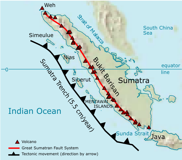
La descripció a la pàgina de descripció del fitxer del repositori compartit es mostra a continuació.
Description

Volcanoes on Sumatra island. See en:List of volcanoes in Indonesia.

Source

own work

Date

2006

Author

User:Indon (myself)

Permission
(Reusing this image)
I, the copyright holder of this work, has published or hereby publishes it under the following license:
GNU head Permission is granted to copy, distribute and/or modify this document under the terms of the GNU Free Documentation license, Version 1.2 or any later version published by the Free Software Foundation; with no Invariant Sections, no Front-Cover Texts, and no Back-Cover Texts. A copy of the license is included in the section entitled "GNU Free Documentation license".

Aragonés | العربية | Asturianu | Български | বাংলা | ইমার ঠার/বিষ্ণুপ্রিয়া মণিপুরী | Brezhoneg | Bosanski | Català | Cebuano | Česky | Dansk | Deutsch | Ελληνικά | English | Esperanto | Español | Eesti | Euskara | فارسی | Suomi | Français | Gaeilge | Galego | עברית | Hrvatski | Magyar | Bahasa Indonesia | Ido | Íslenska | Italiano | 日本語 | ქართული | ភាសាខ្មែរ | 한국어 | Kurdî / كوردی | Latina | Lëtzebuergesch | Lietuvių | Bahasa Melayu | Nnapulitano | Nederlands | ‪Norsk (nynorsk)‬ | ‪Norsk (bokmål)‬ | Occitan | Polski | Português | Română | Русский | Slovenčina | Slovenščina | Shqip | Српски / Srpski | Svenska | తెలుగు | ไทย | Türkçe | Українська | اردو | Tiếng Việt | Volapük | Yorùbá | ‪中文(中国大陆)‬ | ‪中文(台灣)‬ | +/-


Source of maps:

  1. Base map is a truncated public domain image: Image:Southeast asia.svg.
  2. Geological trench system is taken from Simoes, M., et. al. (2004), The Sumatra subduction zone: A case for a locked fault zone extending into the mantle, J. of Geophysical Research, 109. DOI: 10.1029/2003JB002958.
  3. Volcanoes location was traced from en:Google Earth system.

Historial del fitxer

Cliqueu sobre la data/hora per veure el fitxer tal com era aleshores.

Data/HoraDimensionsUsuariComentari
actual03:35, 28 des 2006600×527 (141 KB)Indon ({{Information |Description=Volcanoes on Sumatra island. See en:List of volcanoes in Indonesia. |Source=own work |Date=2006 |Author=User:Indon (myself) |Permission={{GFDL-self}} |other_versions= }} Source of maps: # Base map is a truncated public )

Les següents pàgines enllacen a aquesta imatge: