Imatge:GD-EG-Deir el Bahari-map.png
De Viquipèdia
No hi ha una versió amb una resolució més gran.
GD-EG-Deir_el_Bahari-map.png (443 × 599 píxels, mida de l'arxiu: 104 KB, tipus MIME: image/png)
| | Aquest arxiu és una càrrega compartida, extreta del projecte Wikimedia Commons i pot ser usada per altres projectes. Si voleu disposar de més informació sobre el fitxer, podeu visitar la pàgina original |
[edit] Description
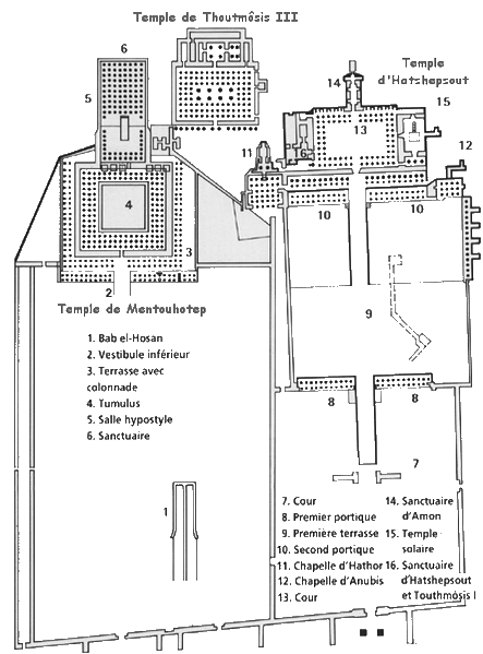
Español: Deir el-Bahari: mapa de los tres templos
Français :
Plan du site de Deir el Bahari (Égypte).
[edit] Licence
| This file is licensed under the Creative Commons Attribution ShareAlike 2.5 License. In short: you are free to share and make derivative works of the file under the conditions that you appropriately attribute it, and that you distribute it only under a license identical to this one. Official license |
[edit] Source
Français :
Dessin de Gérard Ducher (user:Néfermaât).
English:
Drawing by Gérard Ducher
Historial del fitxer
Cliqueu sobre la data/hora per veure el fitxer tal com era aleshores.
| Data/Hora | Dimensions | Usuari | Comentari | |
|---|---|---|---|---|
| actual | 10:30, 30 set 2006 | 443×599 (104 KB) | Janmad | (More light) |
| 00:12, 14 gen 2006 | 446×603 (245 KB) | Néfermaât | (== Description == fr: Plan du site de Deir el Bahari Égypte. ==Source== fr: Dessin de Gérard Ducher (user:Néfermaât). Nefermaat == Licence == {{cc-by-sa-2.5}} ) |
Enllaços a la imatge
Les següents pàgines enllacen a aquesta imatge:

