Imatge:China-Inner-Mongolia.png
De Viquip??dia
No hi ha una versi?? amb una resoluci?? m??s gran.
China-Inner-Mongolia.png??? (268 ?? 218 p??xels, mida de l'arxiu: 15 KB, tipus MIME: image/png)
| | Aquest arxiu ??s una c??rrega compartida, extreta del projecte Wikimedia Commons i pot ser usada per altres projectes. Si voleu disposar de m??s informaci?? sobre el fitxer, podeu visitar la p??gina original |
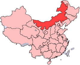
en: Location of Inner Mongolia Autonomous Region in the People's Republic of China. See Locator maps of province-level divisions of the People's Republic of China for more information. The striped area is nominally part of Inner Mongolia, but it is administered by Daxing'anling Prefecture of Heilongjiang Province.
zh: ????????????????????????????????????????????????????????????Locator maps of province-level divisions of the People's Republic of China????????????????????????????????????????????????????????????????????????????????????????????????????????????

Historial del fitxer
Cliqueu sobre la data/hora per veure el fitxer tal com era aleshores.
| Data/Hora | Dimensions | Usuari | Comentari | |
|---|---|---|---|---|
| actual | 16:44, 15 jul 2005 | 268??218 (15 KB) | Schaengel89 | (transparent background) |
| 23:42, 4 juny 2005 | 268??218 (9 KB) | Ran | ('''en''': Location of Inner Mongolia in the People's Republic of China. See Category:Locator maps of province-level divisions of the People's Republic of China for more information. '''zh''': ?????????????????????????????????????????????????????????) |
Enlla??os a la imatge
Les seg??ents p??gines enllacen a aquesta imatge:

