Imatge:Chaudfontaine Liège Belgium Map.png
De Viquipèdia
No hi ha una versió amb una resolució més gran.
Chaudfontaine_Liège_Belgium_Map.png (290 × 220 píxels, mida de l'arxiu: 7 KB, tipus MIME: image/png)
| | Aquest arxiu és una càrrega compartida, extreta del projecte Wikimedia Commons i pot ser usada per altres projectes. Si voleu disposar de més informació sobre el fitxer, podeu visitar la pàgina original |
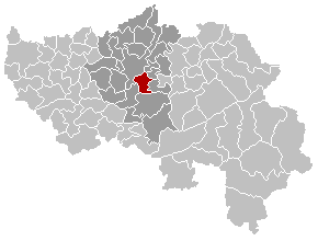
| Description |
English: Map, municipality belgium Chaudfontaine
Français : Carte indiquant la localisation de la commune de Chaudfontaine dans la Province de Liège.
Nederlands: Gemeentekaart Chaudfontaine
|
|---|---|
| Source |
Originally from nl.wikipedia; description page is/was here. |
| Date |
2004-02-20 (first version); 2005-12-24 (last version) |
| Author |
Original uploader was LennartBolks at nl.wikipedia Later versions were uploaded by Westermarck at nl.wikipedia. |
| Permission (Reusing this image) |
Licensed under the GFDL by the author. |
[edit] License information

[edit] Original upload log
(All user names refer to nl.wikipedia)
- 2005-12-24 22:50 Westermarck 290×220×8 (7547 bytes)
- 2004-02-20 18:46 LennartBolks 290×220×8 (5471 bytes) Gemeentekaart, eigen werk
Historial del fitxer
Cliqueu sobre la data/hora per veure el fitxer tal com era aleshores.
| Data/Hora | Dimensions | Usuari | Comentari | |
|---|---|---|---|---|
| actual | 20:31, 11 març 2007 | 290×220 (7 KB) | Siebrand | (See desc added after this upload) |
| 22:56, 4 abr 2005 | 290×220 (5 KB) | Nicnac25 | (Map, municipality belgium Chaudfontaine {{PD}} FR; Carte indiquant la localisation de la commune de Chaudfontaine dans la Province de Liège. EN; Map from w:nl:Gebruiker:LennartBolks/kaartenhoekje in Public Domain by the Author choice. [[Category:Ma) |
Enllaços a la imatge
Les següents pàgines enllacen a aquesta imatge:

