Imatge:Andorra parishes named.png
De Viquipèdia
No hi ha una versió amb una resolució més gran.
Andorra_parishes_named.png (300 × 252 píxels, mida de l'arxiu: 8 KB, tipus MIME: image/png)
| | Aquest arxiu és una càrrega compartida, extreta del projecte Wikimedia Commons i pot ser usada per altres projectes. Si voleu disposar de més informació sobre el fitxer, podeu visitar la pàgina original |
| Description |
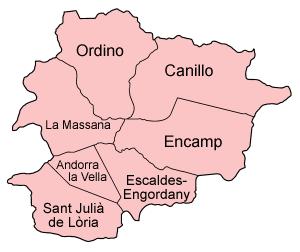
Map of the parishes of Andorra, named in Catalan (local language), compatible with English. The border betwee Canillo and Encamp is vague, this map does its best. Also the borders of Andorra la Vella are somewhat vague. The individual maps are: |
|---|---|
| Source |
Self-made, traced from public domain maps and other resource materials. |
| Date |
December 2004 |
| Author | |
| Permission (Reusing this image) |
Provide attribution, please. See below. |

Historial del fitxer
Cliqueu sobre la data/hora per veure el fitxer tal com era aleshores.
| Data/Hora | Dimensions | Usuari | Comentari | |
|---|---|---|---|---|
| actual | 21:43, 29 des 2004 | 300×252 (8 KB) | Golbez | (Map of the parishes of Andorra. Made by User:Golbez. {{cc-by-sa-2.0}}) |

