Borough londonien de Hillingdon
| Borough londonien de Hillingdon | |
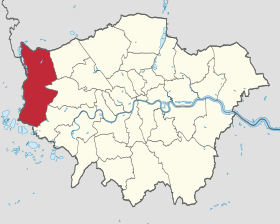
 Carte de localisation du district dans le Grand Londres. |
|
| Administration | |
|---|---|
| Pays | |
| Nation constitutive | Angleterre |
| Comté | Grand Londres |
| Comté cérémonial | Grand Londres |
| Comté traditionnel | Middlesex |
| Statut | Borough |
| Gouvernement | Leader |
| Députés | Nick Hurd, John McDonnell, John Randall |
| London Assembly · Membre |
Ealing and Hillingdon Richard Barnes |
| Maire | Mary O'Connor |
| Code postal | HA, UB, TW |
| Préfixe d'appel | 01895, 01923, 020 |
| Démographie | |
| Population | 266 100 hab. (2010) |
| Densité | 2 300 hab./km2 |
| Rang | 41e / 326 |
| Groupes ethniques | 70,2 % Caucasiens 13,3 % Afro-Caribéen 11,3 % Asiatiques du Sud 2,1 % Chinois |
| Géographie | |
| Coordonnées | 51° 30′ N 0° 27′ O / 51.5, -0.4551° 30′ Nord 0° 27′ Ouest / 51.5, -0.45 |
| Superficie | 11 570 ha = 115,70 km2 |
| Rang | 203e / 326 |
| Liens | |
| Site web | http://www.hillingdon.gov.uk/ |
| modifier | |
Le borough londonien de Hillingdon (« London Borough of Hillingdon ») est un district du Grand Londres. Il fut formé en 1965 par la fusion du district municipal d'Uxbridge, avec les districts urbains Hayes and Harlington, Ruislip-Northwood et Yiewsley and West Drayton dans le Middlesex. C'est dans ce district que trouve Brunel University et l'Aéroport de Londres Heathrow.
Ce district se compose des villes de :
- Cowley
- Eastcote
- Eastcote Village
- Hatton
- Harlington
- Hayes
- Hayes End
- Hayes Town
- Harefield
- Harmondsworth
- Heathrow
- Hillingdon
- Ickenham
- Longford
- Newyears Green
- North Hillingdon
- Northwood
- Northwood Hills
- Ruislip
- Ruislip Common
- Ruislip Gardens
- Ruislip Manor
- Sipson
- South Harefield
- South Ruislip
- Uxbridge
- West Drayton
- Yeading
- Yiewsley

Villes jumelles
-
 Mantes-la-Jolie
 -
 Schleswig
Liens externes
- Hillingdon Association of Voluntary Services
- Index to all Hillingdon streets
- List of parks and open spaces
- Uxbridge Parish website
- Bromley council
- Portail de Londres