Imatge:Walvis Bay map.jpeg
De Viquip??dia
No hi ha una versi?? amb una resoluci?? m??s gran.
Walvis_Bay_map.jpeg??? (372 ?? 420 p??xels, mida de l'arxiu: 34 KB, tipus MIME: image/jpeg)
| | Aquest arxiu ??s una c??rrega compartida, extreta del projecte Wikimedia Commons i pot ser usada per altres projectes. Si voleu disposar de m??s informaci?? sobre el fitxer, podeu visitar la p??gina original |
[edit] Summary
| Description |
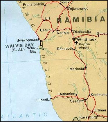
Map of Walvis Bay (Namibia) |
|||
|---|---|---|---|---|
| Source |
From the University of Texas PCL Map Collection [1] |
|||
| Date |
1978 |
|||
| Author | ||||
| Permission (Reusing this image) |
|

Historial del fitxer
Cliqueu sobre la data/hora per veure el fitxer tal com era aleshores.
| Data/Hora | Dimensions | Usuari | Comentari | |
|---|---|---|---|---|
| actual | 06:29, 17 abr 2006 | 372??420 (34 KB) | Foundert | ({{Information| |Description=Map of Walvis Bay (Namibia) from |Source=http://www.lib.utexas.edu/maps/africa/nambia_walvis_pol78.jpg from the University of Texas |Date= 09:59, 27 September 2003 |Author=User:Pascal |Permission=This file has been released in) |
Enlla??os a la imatge
Les seg??ents p??gines enllacen a aquesta imatge:

