[HOME PAGE] [STORES] [CLASSICISTRANIERI.COM] [FOTO] [YOUTUBE CHANNEL]

Imatge:Tokyobay landsat.jpg - Viquipèdia

Imatge:Tokyobay landsat.jpg

De Viquipèdia

Logo del projecte Wikimedia Commons
Aquest arxiu és una càrrega compartida, extreta del projecte Wikimedia Commons i pot ser usada per altres projectes.
Si voleu disposar de més informació sobre el fitxer, podeu visitar la pàgina original
La descripció a la pàgina de descripció del fitxer del repositori compartit es mostra a continuació.

[edit] Summary

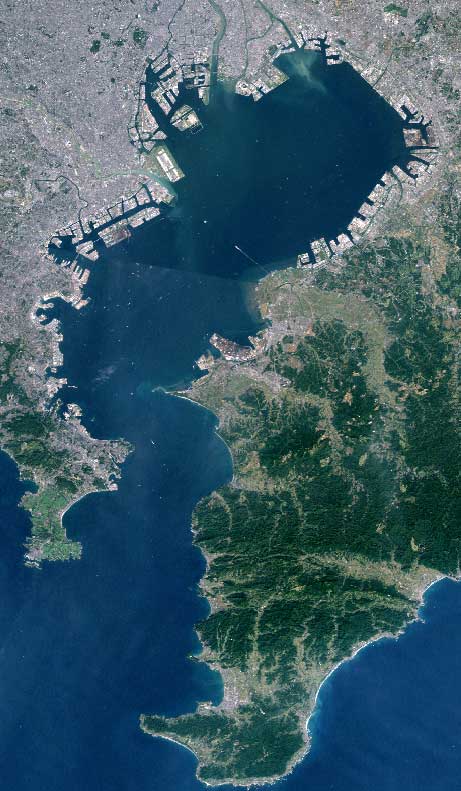
English: Tokyo Bay seen from space. Taken by Landsat.
Español: La Bahía de Tokio, vista desde el espacio.
Deutsch: Bucht von Tokio, Landsat-Aufnahme
Français : La baie de Tōkyō (Landsat).
日本語: 東京湾ランドサット画像 (Landsat).
Nederlands: De Baai van Tokio vanuit de ruimte.
Polski: Zatoka Tokijska.(Landsat).
Svenska: Tokyobukten sedd från rymden, bild tagen från Landsat.)
中文: 東京灣.衛星照片(Landsat).

Source: http://ja.wikipedia.org/wiki/%E7%94%BB%E5%83%8F:Tokyobay_landsat.jpg

[edit] Licensing

GNU head Permission is granted to copy, distribute and/or modify this document under the terms of the GNU Free Documentation license, Version 1.2 or any later version published by the Free Software Foundation; with no Invariant Sections, no Front-Cover Texts, and no Back-Cover Texts. A copy of the license is included in the section entitled "GNU Free Documentation license".

Aragonés | العربية | Asturianu | Български | বাংলা | ইমার ঠার/বিষ্ণুপ্রিয়া মণিপুরী | Brezhoneg | Bosanski | Català | Cebuano | Česky | Dansk | Deutsch | Ελληνικά | English | Esperanto | Español | Eesti | Euskara | فارسی | Suomi | Français | Gaeilge | Galego | עברית | Hrvatski | Magyar | Bahasa Indonesia | Ido | Íslenska | Italiano | 日本語 | ქართული | ភាសាខ្មែរ | 한국어 | Kurdî / كوردی | Latina | Lëtzebuergesch | Lietuvių | Bahasa Melayu | Nnapulitano | Nederlands | ‪Norsk (nynorsk)‬ | ‪Norsk (bokmål)‬ | Occitan | Polski | Português | Română | Русский | Slovenčina | Slovenščina | Shqip | Српски / Srpski | Svenska | తెలుగు | ไทย | Türkçe | Українська | اردو | Tiếng Việt | Volapük | Yorùbá | ‪中文(中国大陆)‬ | ‪中文(台灣)‬ | +/-

Historial del fitxer

Cliqueu sobre la data/hora per veure el fitxer tal com era aleshores.

Data/HoraDimensionsUsuariComentari
actual08:12, 1 abr 2006461×791 (63 KB)Taichi (Tokyo Bay seen from space. Taken by Landsat. Source: http://ja.wikipedia.org/wiki/%E7%94%BB%E5%83%8F:Tokyobay_landsat.jpg Category:Tokyo)

Les següents pàgines enllacen a aquesta imatge: