Imatge:Sy-map.png
De Viquipèdia
No hi ha una versió amb una resolució més gran.
Sy-map.png (328 × 352 píxels, mida de l'arxiu: 12 KB, tipus MIME: image/png)
| | Aquest arxiu és una càrrega compartida, extreta del projecte Wikimedia Commons i pot ser usada per altres projectes. Si voleu disposar de més informació sobre el fitxer, podeu visitar la pàgina original |
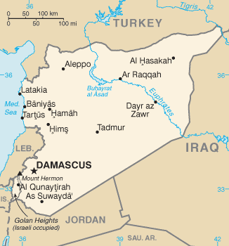
CIA map of syria
| This image is in the public domain because it contains materials that originally came from the United States Central Intelligence Agency's World Factbook.
Deutsch | English | Español | Français | 日本語 | Nederlands | 한국어 | Português | தமிழ் | Magyar | +/- |
 |
 |
This map image should be recreated using vector graphics as an SVG file. This has several advantages; see Commons:Media for cleanup for more information. If an SVG form of this image is already available, please upload it. After uploading an SVG, replace this template with template {{Vector version available|new image name.svg}} in this image. |
|
العربية | Български | Català | Česky | Dansk | Deutsch | English | Esperanto | Español | Français | 한국어 | Italiano | Magyar | Lietuvių | Nederlands | 日本語 | Polski | Português | Română | Русский | Suomi | Svenska | Türkçe | Українська | Tiếng Việt | 中文(繁體) | 中文(简体) | +/- |
|
Historial del fitxer
Cliqueu sobre la data/hora per veure el fitxer tal com era aleshores.
| Data/Hora | Dimensions | Usuari | Comentari | |
|---|---|---|---|---|
| actual | 15:35, 12 maig 2005 | 328×352 (12 KB) | Eirik | (CIA map of syria {{PD-USGov-CIA-WF}} Category:Maps of Syria ) |

