Imatge:Seven United Netherlands Janssonius 1658.jpg
De Viquipèdia
Mida d'aquesta previsualització: 800 × 595 píxels
Imatge en màxima resolució (3.426 × 2.550 píxels, mida de l'arxiu: 1,22 MB, tipus MIME: image/jpeg)
| | Aquest arxiu és una càrrega compartida, extreta del projecte Wikimedia Commons i pot ser usada per altres projectes. Si voleu disposar de més informació sobre el fitxer, podeu visitar la pàgina original |
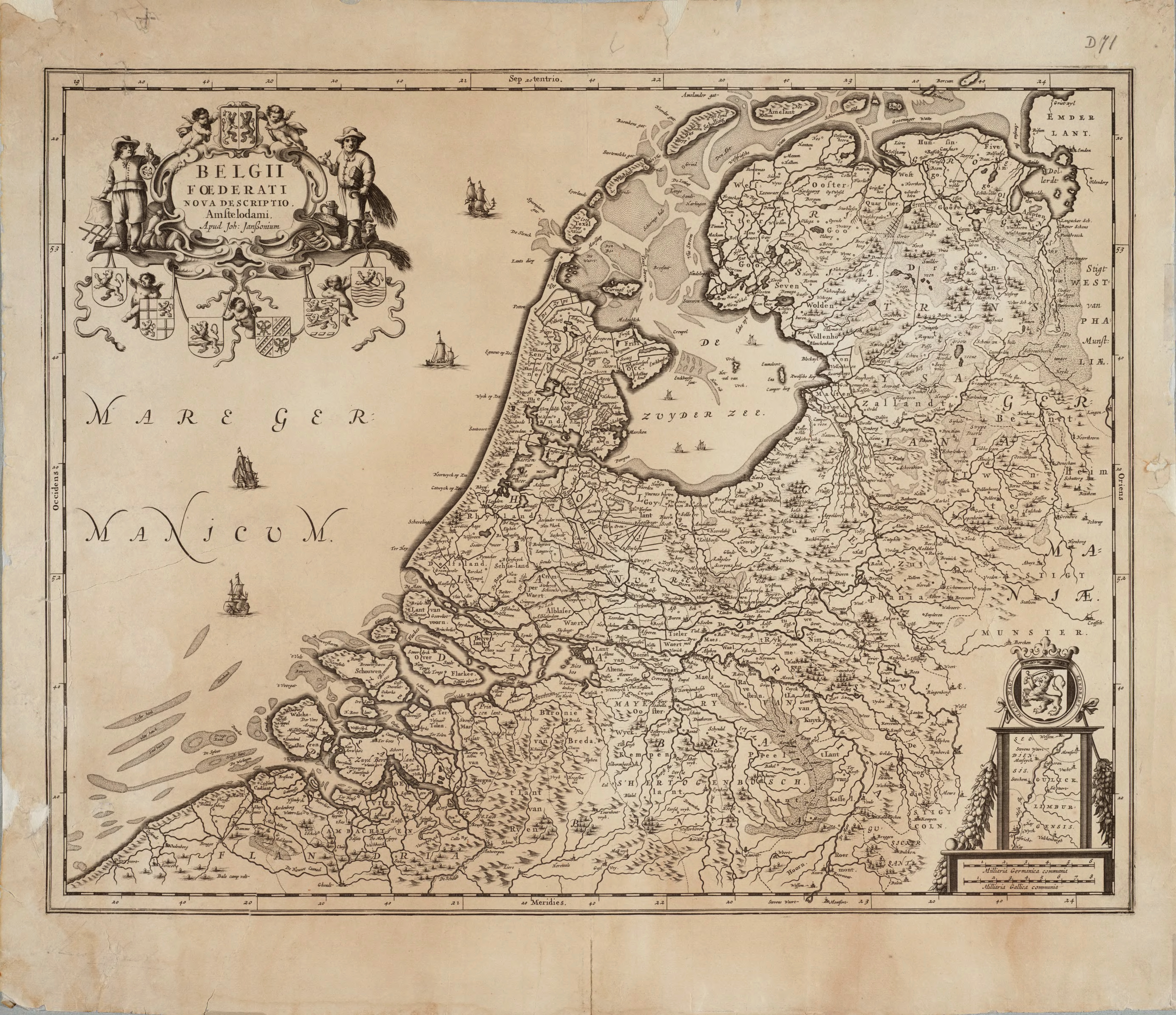
Map of the Republic of the Seven United Netherlands
Drawn by Joannes (or Johannes) Janssonius
Part of his collection Belgii Foederati Nova Descriptio
Published in Amsterdam in 1658
Map predates international copyright law, plus author has sadly deceased some 317 years ago.
| Creator/Artist | ||
|---|---|---|
| Name |
Janssonius, Jan
|
|
| Alternative names |
Jan Jansson, Jan Jansz, Jan Janszoon, Joannes Janssonius
|
|
| Date of birth/death | 1588 | 1664 |
| Location of birth/death | Arnhem | Amsterdam |
| Work period | 1616-1664 | |
| Work location |
Amsterdam
|
|
| This image (or other media file) is in the public domain because its copyright has expired. This applies to the United States, Canada, the European Union and those countries with a copyright term of life of the author plus 70 years.
العربية | Asturianu | Български | Català | Česky | Dansk | Deutsch | English | Ελληνικά | Esperanto | Español | Euskara | فارسی | Français | Gaeilge | Galego | עברית | हिन्दी | Bahasa Indonesia | Italiano | 日本語 | 한국어 | Kurdî / كوردی | Lietuvių | Magyar | Nederlands | Norsk (nynorsk) | Bahasa Melayu | Polski | Português | Română | Русский | Slovenčina | Slovenščina | Shqip | Suomi | Sámegiella | Türkçe | 中文(简体) | 中文(繁體) | 粵語 | +/- |
Historial del fitxer
Cliqueu sobre la data/hora per veure el fitxer tal com era aleshores.
| Data/Hora | Dimensions | Usuari | Comentari | |
|---|---|---|---|---|
| actual | 13:46, 30 jul 2005 | 3.426×2.550 (1,22 MB) | BenTels | (Map of the Republic of the Seven United Netherlands<br> Drawn by Joannes (or ''Johannes'') Janssonius<br> Part of his atlas ''Belgii Foederati Nova Descriptio''<br> Published in Amsterdam in 1658 Map predates international copyright law, plus author ) |
Enllaços a la imatge
Les següents pàgines enllacen a aquesta imatge:

