Imatge:Saint Kitts and Nevis-CIA WFB Map.png
De Viquipèdia
No hi ha una versió amb una resolució més gran.
Saint_Kitts_and_Nevis-CIA_WFB_Map.png (327 × 352 píxels, mida de l'arxiu: 8 KB, tipus MIME: image/png)
| | Aquest arxiu és una càrrega compartida, extreta del projecte Wikimedia Commons i pot ser usada per altres projectes. Si voleu disposar de més informació sobre el fitxer, podeu visitar la pàgina original |
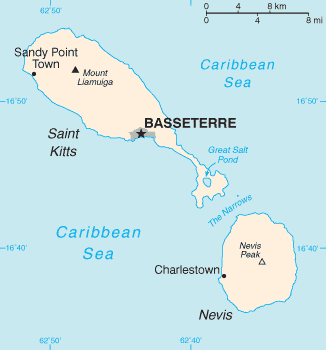
| Description |
English: Map of the Saint Kitts and Nevis
|
|---|---|
| Source |
The World Factbook |
| Date | |
| Author |
n/a |
| Permission (Reusing this image) |
see below |
| Other versions | Image:Basseterre_Map_1.png |
| This image is in the public domain because it contains materials that originally came from the United States Central Intelligence Agency's World Factbook.
Deutsch | English | Español | Français | 日本語 | Nederlands | 한국어 | Português | தமிழ் | Magyar | +/- |
 |
Historial del fitxer
Cliqueu sobre la data/hora per veure el fitxer tal com era aleshores.
| Data/Hora | Dimensions | Usuari | Comentari | |
|---|---|---|---|---|
| actual | 04:18, 18 feb 2006 | 327×352 (8 KB) | Hoshie | (Updated map of Saint Kitts and Nevis from the CIA World Factbook, 10 Jan 06 rev: http://www.cia.gov/cia/publications/factbook/maps/sc-map.gif) |
| 11:17, 27 març 2005 | 330×355 (6 KB) | Wolfman | ({{CIA-map}}) |
Enllaços a la imatge
Les següents pàgines enllacen a aquesta imatge:

