Imatge:Powhatan john smith map.jpg
De Viquip??dia
Mida d'aquesta previsualitzaci??: 415 ?? 599 p??xels
Imatge en m??xima resoluci????? (484 ?? 699 p??xels, mida de l'arxiu: 173 KB, tipus MIME: image/jpeg)
| | Aquest arxiu ??s una c??rrega compartida, extreta del projecte Wikimedia Commons i pot ser usada per altres projectes. Si voleu disposar de m??s informaci?? sobre el fitxer, podeu visitar la p??gina original |
[edit] Summary
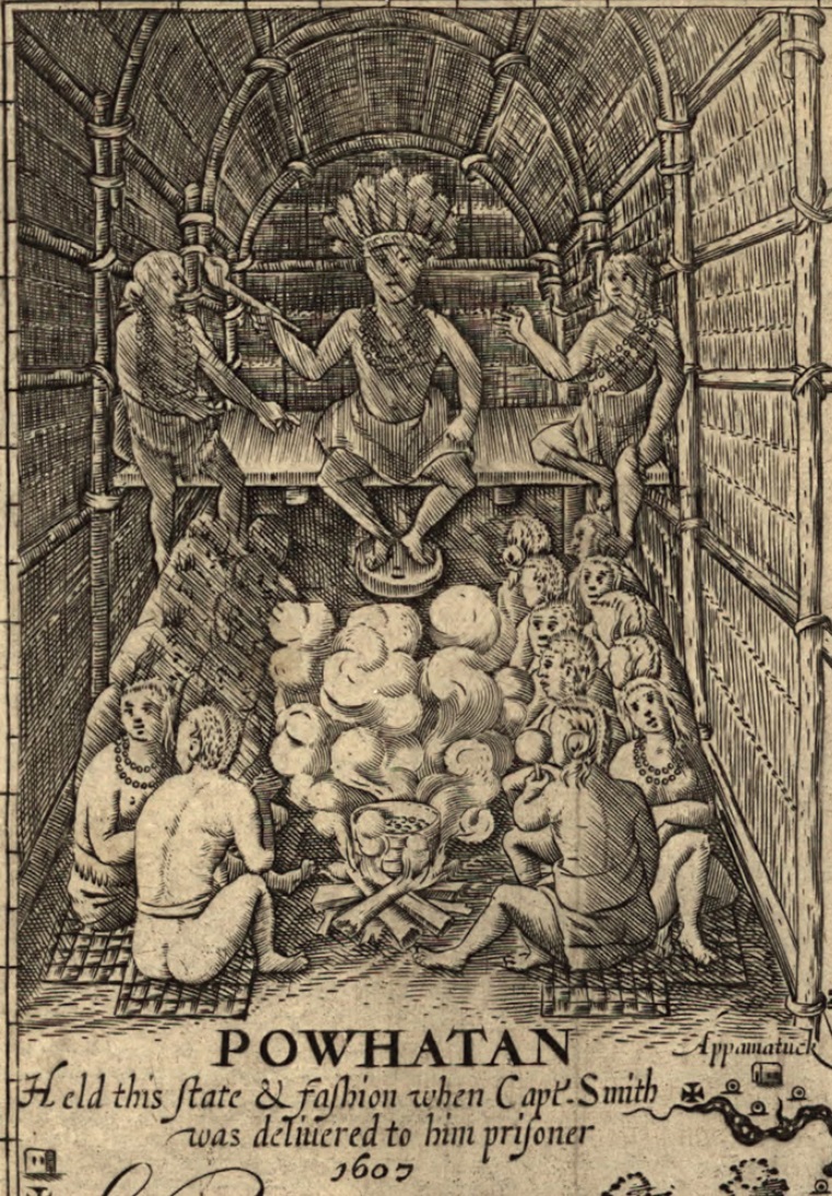
Detail from: Image:Virginia map john smith large.jpg John Smith's Map of Virginia used in various publications, first in 1612. Very large verision of the map. Other verisions available at source URL. Source URL: http://www.virtualjamestown.org/jsmap_large.html
Detail of public domain map made by cropped by uploader who claims it remains public domain.
[edit] Licensing
| This image (or other media file) is in the public domain because its copyright has expired. This applies to the United States, Canada, the European Union and those countries with a copyright term of life of the author plus 70 years.
?????????????? | Asturianu | ?????????????????? | Catal?? | ??esky | Dansk | Deutsch | English | ???????????????? | Esperanto | Espa??ol | Euskara | ?????????? | Fran??ais | Gaeilge | Galego | ?????????? | ?????????????????? | Bahasa Indonesia | Italiano | ????????? | ????????? | Kurd?? / ?????????? | Lietuvi?? | Magyar | Nederlands | ???Norsk (nynorsk)??? | Bahasa Melayu | Polski | Portugu??s | Rom??n?? | ?????????????? | Sloven??ina | Sloven????ina | Shqip | Suomi | S??megiella | T??rk??e | ?????????(??????)??? | ?????????(??????)??? | ?????? | +/- |
Historial del fitxer
Cliqueu sobre la data/hora per veure el fitxer tal com era aleshores.
| Data/Hora | Dimensions | Usuari | Comentari | |
|---|---|---|---|---|
| actual | 20:14, 26 oct 2005 | 484??699 (173 KB) | Bkwillwm | (Detail from: Image:Virginia map john smith large.jpg John Smith's Map of Virginia used in various publications, first in 1612. Very large verision of the map. Other verisions available at source URL. Source URL: http://www.virtualjamestown.org/jsmap_large) |
Enlla??os a la imatge
Les seg??ents p??gines enllacen a aquesta imatge:

