Imatge:Map of Swedish dialects.png
De Viquipèdia
No hi ha una versió amb una resolució més gran.
Map_of_Swedish_dialects.png (461 × 538 píxels, mida de l'arxiu: 46 KB, tipus MIME: image/png)
| | Aquest arxiu és una càrrega compartida, extreta del projecte Wikimedia Commons i pot ser usada per altres projectes. Si voleu disposar de més informació sobre el fitxer, podeu visitar la pàgina original |
| Description |
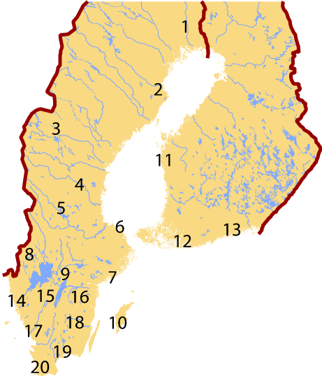
Map of Swedish dialects. Maps of Sweden and Finland adapted from [1] and [2], the International Nuclear Safety Center at Argonne National Laboratory. |
|---|---|
| Source |
self-made |
| Date |
Created 17. May. 2005 |
| Author |
Jeffrey Connell (IceKarma) |
| Permission (Reusing this image) |
Derived from public domain images from the Department of Energy. See [3]. |
See Swedish language#Dialects for index.
| This image is a work of a United States Department of Energy (or predecessor organization) employee, taken or made during the course of an employee's official duties. As a work of the U.S. federal government, the image is in the public domain.
Please note that national laboratories operate under varying licences and some are not free. Check the site policies of any national lab before crediting it with this tag. |
 |
 |
This map image should be recreated using vector graphics as an SVG file. This has several advantages; see Commons:Media for cleanup for more information. If an SVG form of this image is already available, please upload it. After uploading an SVG, replace this template with template {{Vector version available|new image name.svg}} in this image. |
|
العربية | Български | Català | Česky | Dansk | Deutsch | English | Esperanto | Español | Français | 한국어 | Italiano | Magyar | Lietuvių | Nederlands | 日本語 | Polski | Português | Română | Русский | Suomi | Svenska | Türkçe | Українська | Tiếng Việt | 中文(繁體) | 中文(简体) | +/- |
|
Historial del fitxer
Cliqueu sobre la data/hora per veure el fitxer tal com era aleshores.
| Data/Hora | Dimensions | Usuari | Comentari | |
|---|---|---|---|---|
| actual | 03:28, 19 feb 2007 | 461×538 (46 KB) | Tene | (Optimised (0)) |
| 23:43, 17 maig 2005 | 461×538 (51 KB) | IceKarma | ||
| 23:28, 17 maig 2005 | 461×538 (51 KB) | IceKarma | ||
| 23:06, 17 maig 2005 | 614×716 (84 KB) | IceKarma | ({{Information| |Description=Map of Swedish dialects. Maps of Sweden and Finland adapted from [http://www.insc.anl.gov/pwrmaps/map/sweden.php] and [http://www.insc.anl.gov/pwrmaps/map/finland.php], the International Nuclear Safety Center at Argonne Natio) |
Enllaços a la imatge
Les següents pàgines enllacen a aquesta imatge:

