Imatge:Luxembourg administrative subdivisions coloured.gif
De Viquipèdia
Mida d'aquesta previsualització: 444 × 599 píxels
Imatge en màxima resolució (600 × 809 píxels, mida de l'arxiu: 30 KB, tipus MIME: image/gif)
| | Aquest arxiu és una càrrega compartida, extreta del projecte Wikimedia Commons i pot ser usada per altres projectes. Si voleu disposar de més informació sobre el fitxer, podeu visitar la pàgina original |
[edit] Summary
| Description |
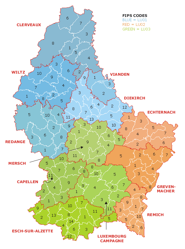
Map of the administrative divisions of Luxembourg. Districts, cantons, and communes are marked and numbered according to FIPS code. |
|---|---|
| Source |
Own work based on w:Image:Luxembourg.geohive.gif, which previously had all rights released by its original author and publisher, GeoHive. Updated for the commune mergers of 2006-01-01. |
| Date |
21 July 2006 |
| Author | |
| Permission (Reusing this image) |
Released into public domain. See licence below. |
[edit] Licensing
| I, the copyright holder of this work, hereby release it into the public domain. This applies worldwide. In case this is not legally possible: Afrikaans | Alemannisch | Aragonés | العربية | Asturianu | Български | Català | Česky | Cymraeg | Dansk | Deutsch | Eʋegbe | Ελληνικά | English | Español | Esperanto | Euskara | Estremeñu | فارسی | Français | Galego | 한국어 | हिन्दी | Hrvatski | Ido | Bahasa Indonesia | Íslenska | Italiano | עברית | Kurdî / كوردی | Latina | Lietuvių | Latviešu | Magyar | Македонски | Bahasa Melayu | Nederlands | Norsk (bokmål) | Norsk (nynorsk) | 日本語 | Polski | Português | Ripoarisch | Română | Русский | Shqip | Slovenčina | Slovenščina | Српски / Srpski | Svenska | ไทย | Tagalog | Türkçe | Українська | Tiếng Việt | Walon | 中文(简体) | 中文(繁體) | zh-yue-hant | +/- |
Historial del fitxer
Cliqueu sobre la data/hora per veure el fitxer tal com era aleshores.
| Data/Hora | Dimensions | Usuari | Comentari | |
|---|---|---|---|---|
| actual | 02:19, 21 jul 2006 | 600×809 (30 KB) | Bastin8 | ({{Information |Description=Map of the administrative divisions of Luxembourg. Districts, cantons, and communes are marked and numbered according to FIPS code. |Source=Own work based on w:Image:Luxembourg.geohive.gif, which previously had all rights r) |
Enllaços a la imatge
Les següents pàgines enllacen a aquesta imatge:

