Imatge:LocationGreece.png
De Viquipèdia
No hi ha una versió amb una resolució més gran.
LocationGreece.png (250 × 115 píxels, mida de l'arxiu: 5 KB, tipus MIME: image/png)
| | Aquest arxiu és una càrrega compartida, extreta del projecte Wikimedia Commons i pot ser usada per altres projectes. Si voleu disposar de més informació sobre el fitxer, podeu visitar la pàgina original |
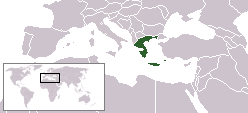
Location map for Greece.
Originally created for English Wikipedia by Vardion.
| This image has been (or is hereby) released into the public domain by its author, Vardion at the English Wikipedia project. This applies worldwide. In case this is not legally possible: |
 |
This map image should be recreated using vector graphics as an SVG file. This has several advantages; see Commons:Media for cleanup for more information. If an SVG form of this image is already available, please upload it. After uploading an SVG, replace this template with template {{Vector version available|new image name.svg}} in this image. |
|
العربية | Български | Català | Česky | Dansk | Deutsch | English | Esperanto | Español | Français | 한국어 | Italiano | Magyar | Lietuvių | Nederlands | 日本語 | Polski | Português | Română | Русский | Suomi | Svenska | Türkçe | Українська | Tiếng Việt | 中文(繁體) | 中文(简体) | +/- |
|
Historial del fitxer
Cliqueu sobre la data/hora per veure el fitxer tal com era aleshores.
| Data/Hora | Dimensions | Usuari | Comentari | |
|---|---|---|---|---|
| actual | 13:54, 4 juny 2006 | 250×115 (5 KB) | Rain74 | (added Serbia-Montenegro border) |
| 22:39, 27 juny 2005 | 250×115 (4 KB) | Andrew pmk | (optimize) | |
| 17:29, 5 des 2004 | 250×115 (7 KB) | EugeneZelenko | (Location map for Greece (Hellas).<br/>Originally created for English Wikipedia by Vardion.<br/>{{GFDL}}) |
Enllaços a la imatge
Les següents pàgines enllacen a aquesta imatge:

