Imatge:Landsat7 dry valley lrg.jpg
De Viquipèdia
Mida d'aquesta previsualització: 800 × 466 píxels
Imatge en màxima resolució (6.245 × 3.640 píxels, mida de l'arxiu: 2,96 MB, tipus MIME: image/jpeg)
| | Aquest arxiu és una càrrega compartida, extreta del projecte Wikimedia Commons i pot ser usada per altres projectes. Si voleu disposar de més informació sobre el fitxer, podeu visitar la pàgina original |
[edit] Summary
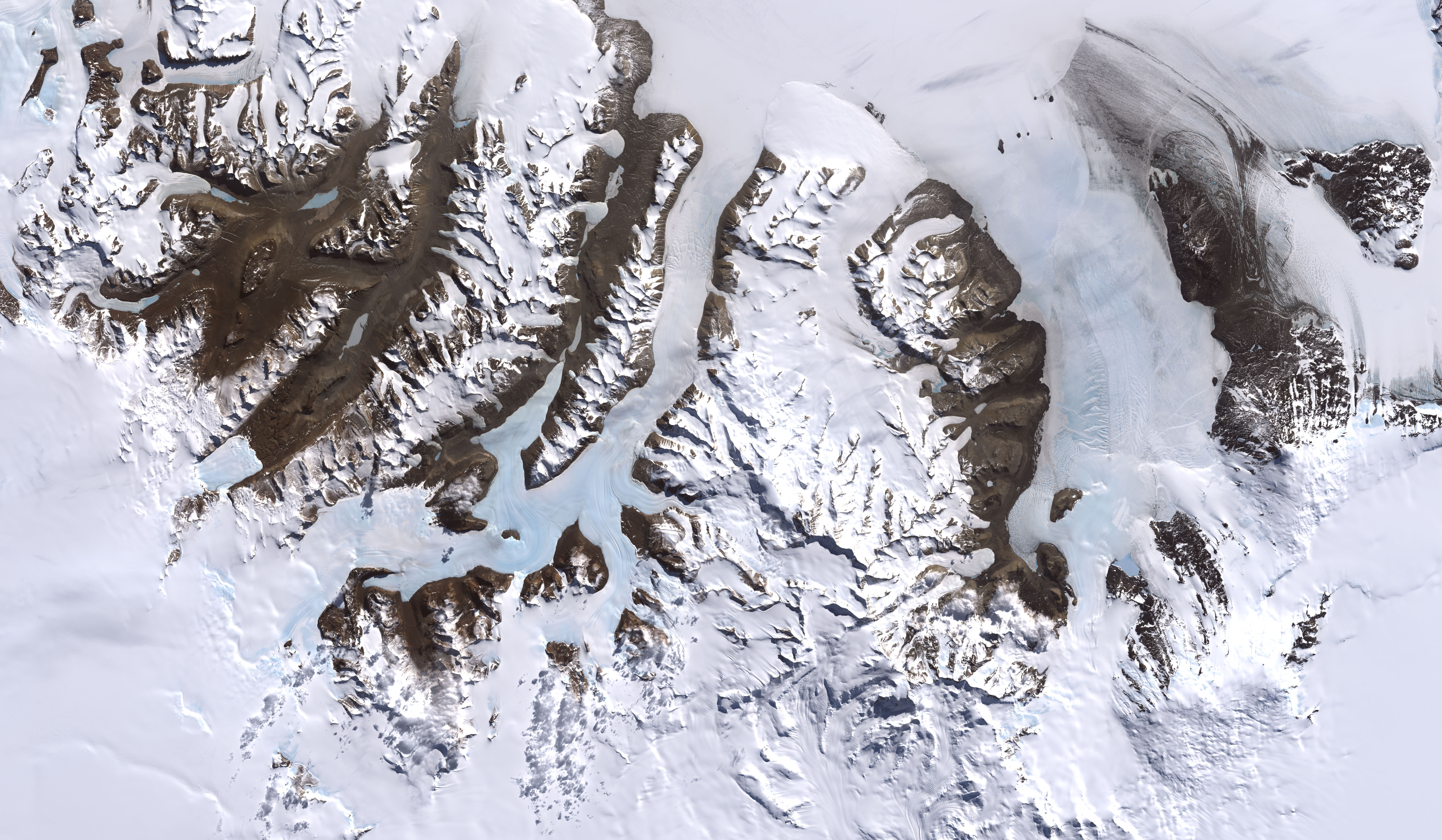
McMurdo Dry Valleys, Antarctica
From: http://visibleearth.nasa.gov/view_rec.php?id=2414
Credit: Image by Robert Simmon, based on data provided by the NASA GSFC Oceans and Ice Branch and the Landsat 7 Science Team
One of the few areas of Antarctica not covered by thousands of meters of ice, the McMurdo Dry Valleys stand out in this satellite image. For a few weeks each summer temperatures are warm enough to melt glacial ice, creating streams that feed freshwater lakes that lie at the bottom of the valleys. Beneath a cap of ice these lakes remains unfrozen year-round, supporting colonies of bacteria and phytoplankton. Over the past 14 years, however, summers have been colder than usual, and the lakes are becoming more and more frozen. If the trend continues, the biological communities they support may go into hibernation.
Most of Antarctica has cooled along with the Dry Valleys, in contrast to much of the rest of the Earth, which has warmed over the past 100 years. No one knows if the trend is related to global climate, or just a quirk in the weather.
This image was acquired by Landsat 7’s Enhanced Thematic Mapper plus (ETM+) instrument on December 18, 1999.
[edit] Licensing
| This work is in the public domain in the United States because it is a work of the United States Federal Government under the terms of Title 17, Chapter 1, Section 105 of the US Code. See Copyright.
Note: This only applies to works of the Federal Government and not to the work of any individual U.S. state, territory, commonwealth, county, municipality, or any other subdivision. العربية | Български | Česky | Deutsch | English | Español | Français | Magyar | Italiano | 日本語 | 한국어 | Polski | Português | 中文(繁體) | 中文(简体) | +/- |
 |
Historial del fitxer
Cliqueu sobre la data/hora per veure el fitxer tal com era aleshores.
| Data/Hora | Dimensions | Usuari | Comentari | |
|---|---|---|---|---|
| actual | 22:45, 4 jul 2007 | 6.245×3.640 (2,96 MB) | Xhienne | (Losslessly removed progressive marker so that a thumbnail can be generated) |
| 02:51, 2 gen 2006 | 6.245×3.640 (2,91 MB) | Aude | (McMurdo Dry Valleys, Antarctica ''From: [http://visibleearth.nasa.gov/view_rec.php?id=2414 http://visibleearth.nasa.gov/view_rec.php?id=2414] Credit: Image by Robert Simmon, based on data provided by the NASA GSFC Oceans and Ice Branch and the Landsat 7) |
Enllaços a la imatge
Les següents pàgines enllacen a aquesta imatge:

