Imatge:ItalianMareNostrum.jpg
De Viquipèdia
Mida d'aquesta previsualització: 800 × 402 píxels
Imatge en màxima resolució (1.254 × 630 píxels, mida de l'arxiu: 319 KB, tipus MIME: image/jpeg)
| | Aquest arxiu és una càrrega compartida, extreta del projecte Wikimedia Commons i pot ser usada per altres projectes. Si voleu disposar de més informació sobre el fitxer, podeu visitar la pàgina original |
[edit] Dettagli
| Description |
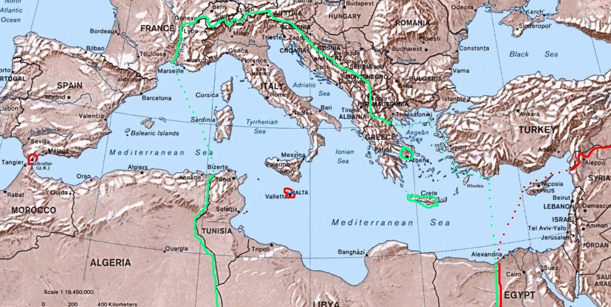
Map of Italian "Mare Nostrum" (Italian Mediterranean), showing inside the green line & dots the italian areas in the Mediterranean sea during summer 1942 (in red those under British control). The remaining areas were under Axis control (Germany,Bulgary and Vichy France) and under friendly neutrality (Spain, Turkey). |
|---|---|
| Source |
self-made (I have based my work on the original Commons Image:Mediterranean Relief.jpg, licensed PD-USGov) |
| Date |
August 2007 |
| Author | |
| Permission (Reusing this image) |
see below |
[edit] Licensing
| I, the copyright holder of this work, hereby release it into the public domain. This applies worldwide. In case this is not legally possible: Afrikaans | Alemannisch | Aragonés | العربية | Asturianu | Български | Català | Česky | Cymraeg | Dansk | Deutsch | Eʋegbe | Ελληνικά | English | Español | Esperanto | Euskara | Estremeñu | فارسی | Français | Galego | 한국어 | हिन्दी | Hrvatski | Ido | Bahasa Indonesia | Íslenska | Italiano | עברית | Kurdî / كوردی | Latina | Lietuvių | Latviešu | Magyar | Македонски | Bahasa Melayu | Nederlands | Norsk (bokmål) | Norsk (nynorsk) | 日本語 | Polski | Português | Ripoarisch | Română | Русский | Shqip | Slovenčina | Slovenščina | Српски / Srpski | Svenska | ไทย | Tagalog | Türkçe | Українська | Tiếng Việt | Walon | 中文(简体) | 中文(繁體) | zh-yue-hant | +/- |
Historial del fitxer
Cliqueu sobre la data/hora per veure el fitxer tal com era aleshores.
| Data/Hora | Dimensions | Usuari | Comentari | |
|---|---|---|---|---|
| actual | 04:21, 21 ago 2007 | 1.254×630 (319 KB) | Brunodambrosio | ({{Information |Description=Map of Italian "Mare Nostrum" (Italian Mediterranean), showing inside the green line & dots the italian areas in the Mediterranean sea during summer 1942 (in red those under British control). The remaining areas were under Axis ) |
Enllaços a la imatge
Les següents pàgines enllacen a aquesta imatge:

