[HOME PAGE] [STORES] [CLASSICISTRANIERI.COM] [FOTO] [YOUTUBE CHANNEL]

Imatge:Cantal-Position.png - Viquipèdia

Imatge:Cantal-Position.png

De Viquipèdia

Logo del projecte Wikimedia Commons
Aquest arxiu és una càrrega compartida, extreta del projecte Wikimedia Commons i pot ser usada per altres projectes.
Si voleu disposar de més informació sobre el fitxer, podeu visitar la pàgina original
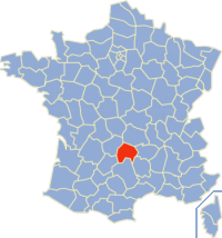
La descripció a la pàgina de descripció del fitxer del repositori compartit es mostra a continuació.
Description
English: Map of France with highlighted department of Cantal (15).
English: Carte de localisation du département français du Cantal (15).
Source

originally uploaded to the French Wikipedia.

Date

19 déc 2003 à 19:20

Author

fr:Utilisateur:Rinaldum

Permission
(Reusing this image)
GNU head Permission is granted to copy, distribute and/or modify this document under the terms of the GNU Free Documentation license, Version 1.2 or any later version published by the Free Software Foundation; with no Invariant Sections, no Front-Cover Texts, and no Back-Cover Texts. A copy of the license is included in the section entitled "GNU Free Documentation license".

Aragonés | العربية | Asturianu | Български | বাংলা | ইমার ঠার/বিষ্ণুপ্রিয়া মণিপুরী | Brezhoneg | Bosanski | Català | Cebuano | Česky | Dansk | Deutsch | Ελληνικά | English | Esperanto | Español | Eesti | Euskara | فارسی | Suomi | Français | Gaeilge | Galego | עברית | Hrvatski | Magyar | Bahasa Indonesia | Ido | Íslenska | Italiano | 日本語 | ქართული | ភាសាខ្មែរ | 한국어 | Kurdî / كوردی | Latina | Lëtzebuergesch | Lietuvių | Bahasa Melayu | Nnapulitano | Nederlands | ‪Norsk (nynorsk)‬ | ‪Norsk (bokmål)‬ | Occitan | Polski | Português | Română | Русский | Slovenčina | Slovenščina | Shqip | Српски / Srpski | Svenska | తెలుగు | ไทย | Türkçe | Українська | اردو | Tiếng Việt | Volapük | Yorùbá | ‪中文(中国大陆)‬ | ‪中文(台灣)‬ | +/-

GNU head This work is free software; you can redistribute it and/or modify it under the terms of the GNU General Public License as published by the Free Software Foundation; either version 2 of the License, or any later version. This work is distributed in the hope that it will be useful, but WITHOUT ANY WARRANTY; without even the implied warranty of MERCHANTABILITY or FITNESS FOR A PARTICULAR PURPOSE. See version 2 and version 3 of the GNU General Public License for more details.

العربية | Català | Česky | Deutsch | Ελληνικά | English | Español | فارسی | Français | Italiano | 日本語 | Nederlands | Polski | Português | Русский | Slovenčina | Svenska | Türkçe | ‪中文(简体)‬ | ‪中文(繁體)‬ | +/-


The image was created by fr:Utilisateur:Rinaldum, and :

  • 19 déc 2003 à 19:20 . . Rinaldum (38242 octets) (Carte de localisation du département français 15licence GPL et GFDL)

Historial del fitxer

Cliqueu sobre la data/hora per veure el fitxer tal com era aleshores.

Data/HoraDimensionsUsuariComentari
actual04:36, 3 març 2006200×214 (41 KB)Bayo (patch de la Corse)
22:19, 3 gen 2005200×214 (37 KB)Auro (Map of France with highlighted #15 department. (taken from fr.wiki) {{GFDL}})

Les següents pàgines enllacen a aquesta imatge: