Imatge:Cantabros.png
De Viquipèdia
No hi ha una versió amb una resolució més gran.
Cantabros.png (763 × 519 píxels, mida de l'arxiu: 141 KB, tipus MIME: image/png)
| | Aquest arxiu és una càrrega compartida, extreta del projecte Wikimedia Commons i pot ser usada per altres projectes. Si voleu disposar de més informació sobre el fitxer, podeu visitar la pàgina original |
| Description |
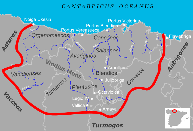
Español: Cantabria durante el periodo de las Guerras Cántabras. El mapa señala las fronteras del territorio cántabro en relación con la Cantabria actual así como las distintas tribus que lo habitaban, los pueblos vecinos, ciudades y accidentes geográficos interpretados a partir de fuentes clásicas.
English: Roman Cantabria during the Cantabrian Wars. The map indicates the borders of the cantabrian territory in relation to the present Cantabria as well as the different tribes who inhabited it, the neighboring people, towns and geographic features.
|
|---|---|
| Source |
own work |
| Date |
Mayo de 2005 |
| Author | |
| Permission (Reusing this image) |
see below |
[edit] Summary
- Title
Español: Mapa de la Cantabria Antigua
English: Map of the ancient Cantabria
- Created with:
Inkscape
[edit] Licensing
|

Historial del fitxer
Cliqueu sobre la data/hora per veure el fitxer tal com era aleshores.
| Data/Hora | Dimensions | Usuari | Comentari | |
|---|---|---|---|---|
| actual | 22:50, 23 set 2005 | 763×519 (141 KB) | Tony Rotondas | (*'''Title''' {{Spanish}} Mapa de la Cantabria antigua <br /> {{English}} Map of the ancient Cantabria<br /> *'''Description''' {{Spanish}} Cantabria romana durante el periodo de las Guerras Cántabras. El mapa señala las fronteras del territorio cánt) |
| 13:40, 7 maig 2005 | 763×519 (292 KB) | Tony Rotondas |
Enllaços a la imatge
Les següents pàgines enllacen a aquesta imatge:

