Imatge:Bolivia-Pando.png
De Viquipèdia
No hi ha una versió amb una resolució més gran.
Bolivia-Pando.png (100 × 113 píxels, mida de l'arxiu: 2 KB, tipus MIME: image/png)
| | Aquest arxiu és una càrrega compartida, extreta del projecte Wikimedia Commons i pot ser usada per altres projectes. Si voleu disposar de més informació sobre el fitxer, podeu visitar la pàgina original |
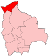
| Description |
Map of Bolivia showing Pando department. Deutsch: Lage des Departamento Pando in Bolivien
English: Map of Bolivia showing Pando department
Esperanto: Mapo de Bolivio montranta _Pando_ departemento
|
|---|---|
| Source |
Self-made, traced from public domain UN or CIA maps. |
| Date |
December 2004 |
| Author | |
| Permission (Reusing this image) |
Provide attribution, please. See below. |
| Other versions | See Image:Bolivia departments named.png for the map of the districts. |

Historial del fitxer
Cliqueu sobre la data/hora per veure el fitxer tal com era aleshores.
| Data/Hora | Dimensions | Usuari | Comentari | |
|---|---|---|---|---|
| actual | 06:14, 20 set 2006 | 100×113 (2 KB) | Golbez | (Reverted to earlier revision) |
| 17:45, 9 oct 2005 | 100×113 (1 KB) | Alhen | (Modified by Alhen) | |
| 23:27, 27 des 2004 | 100×113 (2 KB) | Golbez | (Map of Bolivia showing Pando department. Made by User:Golbez. {{cc-by-sa-2.0}}) | |
| 14:51, 25 set 2004 | 100×114 (3 KB) | Robbot | (This image was copied from en.wikipedia.org. The original description was: Map of Bolivia showing Pando department. Made by Golbez. {{GFDL}} en:Image:Bolivia-Pando.png) |
Enllaços a la imatge
Les següents pàgines enllacen a aquesta imatge:

