
File:US Secession map 1861.svg
Size of this preview: 640 × 393 pixels.
| |
This is a file from the Wikimedia Commons. Information from its description page there is shown below.
Commons is a freely licensed media file repository. You can help. |
| Description |
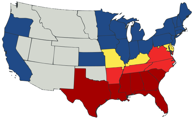
English: United States map of 1861, show affiliation of states and territories regarding the Secession War (Civil War.) Legend:
States that seceded before April 15, 1861
States that seceded after April 15, 1861
Union states that permitted slavery
Union states that forbade slavery
Territories, unaffiliated
|
||
| Date | 23 February 2007 | ||
| Source |
|
||
| Author | Júlio Reis | ||
| Permission ( Reusing this file) |
See below. |
| This file is licensed under the Creative Commons Attribution-Share Alike 3.0 Unported license. | ||
|
File usage
The following pages on Schools Wikipedia link to this image (list may be incomplete):
Metadata
About Schools Wikipedia
Wikipedia for Schools is one of SOS Childrens Villages' many educational projects. By supporting vulnerable children right through to adulthood, SOS Children makes a lasting difference to the lives of thousands of people. Education is a key part of our work, and our schools provide high-quality teaching to the children in our care. Try to find out how you can help children in other countries on our web site.