
File:Early Rus.png
| |
This is a file from the Wikimedia Commons. Information from its description page there is shown below.
Commons is a freely licensed media file repository. You can help. |
 |
This map image could be recreated using vector graphics as an SVG file. This has several advantages; see Commons:Media for cleanup for more information. If an SVG form of this image is already available, please upload it. After uploading an SVG, replace this template with {{ vector version available|new image name.svg}}. |
 |
This map has been uploaded by Electionworld from en.wikipedia.org to enable the |
Summary
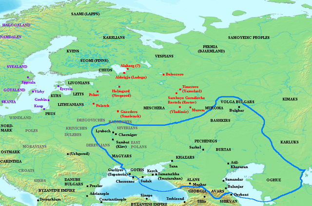
Map showing the distribution of early Varangian settlement, mid-ninth century CE. Varangian settlements shown in red, other Scandinavian settlement in purple. Grey names indicate locations of Slavic tribes. Blue outline indicates extent of Khazar sphere of influence.
Names in parenthesis indicate names of more familiar, and later, cities built on approximately the same site as the settlements named.
Note:There is controversy over the name of the original settlement at modern-day Rostov. Later Norse sources referred to the town (even in its earliest periods) as Rostofa or Ráðstofa. However, the original settlement (relevant to the period of this map) was at nearby Sarskoye Gorodishche, a later designation meaning simply "Citadel on the Sara River." The original name used by the town's Varangian inhabitants is unknown. For more information, see Rostov and Sarskoye Gorodishche.
Sources
- Christian, David. A History of Russia, Mongolia and Central Asia. Blackwell, 1999. ISBN 0631208143.
- Dolukhanov, P.M. The Early Slavs: Eastern Europe and the Initial Settlement to Kievan Rus'. London: Longman, 1996. ISBN 0582236185.
- Franklin, Simon and Jonathan Shepard. The Emergence of Rus 750-1200. London: Longman, 1996. ISBN 058249091X.
- Haywood, John. Cassell Atlas of World History.
Licensing
|

File usage
Find out more
Wikipedia for Schools is one of SOS Children's many educational projects. SOS Children believes that a decent childhood is essential to a happy, healthy. Our community work brings families new opportunities through education, healthcare and all manner of support. Sponsoring a child is a great way to help children who need your support.