
File:Regions of Somaliland.png

Size of this preview: 640 × 418 pixels.
| |
This is a file from the Wikimedia Commons. Information from its description page there is shown below.
Commons is a freely licensed media file repository. You can help. |
Summary
| Description | Regional Map of Somaliland, based on: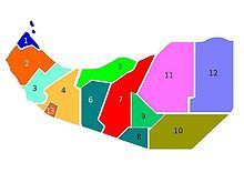 |
||
| Date | 24 July 2009 | ||
| Source | I ( AniRaptor2001 ( talk)) created this work entirely by myself. | ||
| Author | AniRaptor2001 (Transferred to WikiCOmmons from English Wiki by Zac allan ( talk)) | ||
| Permission ( Reusing this file) |
|

 |
This map image could be recreated using vector graphics as an SVG file. This has several advantages; see Commons:Media for cleanup for more information. If an SVG form of this image is already available, please upload it. After uploading an SVG, replace this template with {{ vector version available|new image name.svg}}. |
File usage
The following pages on Schools Wikipedia link to this image (list may be incomplete):
Metadata
What is Schools Wikipedia?
SOS Children chose the best bits of Wikipedia to help you learn. In 133 nations around the world, SOS Childrens Villages works to bring better education and healthcare to families in desperate need of support. Have you heard about child sponsorship? Visit our web site to find out.