
File:Hurricane Dennis 10 july 2005 1615Z.jpg
Size of this preview: 370 × 479 pixels.
| |
This is a file from the Wikimedia Commons. Information from its description page there is shown below.
Commons is a freely licensed media file repository. You can help. |
|
Warning |
Some browsers may have trouble displaying this image at full resolution: This image has a large number of pixels and may either not load properly or cause your browser to freeze. | Interactive large-image-viewer ( non-Flash) |
|---|
Summary
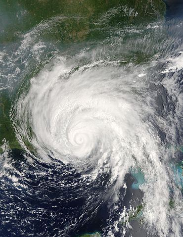
| Description | Hurricane Dennis was bearing down on the Gulf Coast of the United States on July 10, 2005, at 12:15 p.m. (16:15 UTC) when the Moderate Resolution Imaging Spectroradiometer on NASA's Terra satellite captured this image. With winds of 140 miles per hour (225 kph), Dennis was a powerful Category 4 storm just hours away from making landfall. At the time this image was taken, the eye of the storm was about 55 miles (90 kilometers) south, southeast of Pensacola, Florida, and the storm was moving northwest at about 18 miles per hour (29 kph). The size of the storm put clouds of rain over most of the southeastern United States well before the storm came ashore. In this image, Dennis covers all of Florida, Alabama, Mississippi, and stretches over parts of Louisiana. The northern fringes of the storm appear to be over Tennessee and North Carolina. For additional information and warnings about this storm, please visit the National Hurricane Centre. This image is available in additional resolutions from the MODIS Rapid Response Team. |
|||||
| Date | 10 July 2005 | |||||
| Source | http://earthobservatory.nasa.gov/NaturalHazards/natural_hazards_v2.php3?img_id=12947 | |||||
| Author | NASA image courtesy Jacques Descloitres, MODIS Rapid Response Team, NASA GSFC | |||||
| Permission ( Reusing this file) |
|


File usage
The following pages on Schools Wikipedia link to this image (list may be incomplete):
More information
Wikipedia for Schools is one of SOS Childrens Villages' many educational projects. More than 2 million people benefit from the global charity work of SOS Children's Villages, and our work in 133 countries around the world is vital to ensuring a better future for vulnerable children. If you'd like to help, why not learn how to sponsor a child?