
File:Second World War Europe.png
Size of this preview: 498 × 480 pixels.
| |
This is a file from the Wikimedia Commons. Information from its description page there is shown below.
Commons is a freely licensed media file repository. You can help. |
Summary
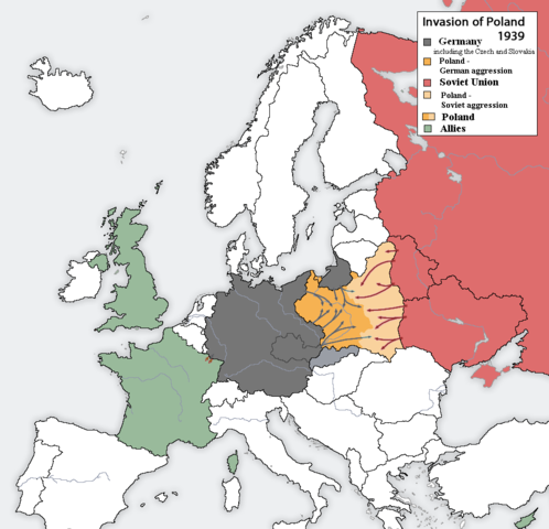
| Description | English: Polish Defensive War 1939. The map shows the beginning of the Second World War in September 1939 in a wider European context. Second Polish Republic, one of the three original allies of World War II was invaded and divided between the Third Reich and Soviet Union, acting together in line with the secret protocol of the Molotov-Ribbentrop Pact, dividing Central and Eastern Europe between the two countries. The Polish allies of that time were France and Great Britain.
|
||||||||||||||
| Date | 4 August 2006 (original upload date) | ||||||||||||||
| Source | Transferred from en.wikipedia to Commons. | ||||||||||||||
| Author | Listowy at English Wikipedia. | ||||||||||||||
| Permission ( Reusing this file) |
|

 |
This map image could be recreated using vector graphics as an SVG file. This has several advantages; see Commons:Media for cleanup for more information. If an SVG form of this image is already available, please upload it. After uploading an SVG, replace this template with {{ vector version available|new image name.svg}}. |
File usage
The following pages on Schools Wikipedia link to this image (list may be incomplete):
Metadata
Wikipedia for Schools...
SOS Children aims to make Wikipedia suitable for young learners. SOS Childrens Villages is a global charity founded in 1949 to give children who have lost everything the childhood they deserve. Why not try to find out more about sponsoring a child?