
File:AlaskaQuake-FourthAve.jpg
Size of this preview: 623 × 480 pixels.
| |
This is a file from the Wikimedia Commons. Information from its description page there is shown below.
Commons is a freely licensed media file repository. You can help. |
| Description |
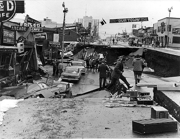
English: Damage to Fourth Avenue, en:Anchorage, Alaska, caused by the en:Good Friday Earthquake. Collapse of Fourth Avenue near C Street in Anchorage due to a landslide caused by the earthquake. Before the shock, the sidewalk on the left, which is in the graben, was at street level on the right. The graben subsided 11 feet in response to 14 feet of horizontal movement.
|
| Date | 1964 |
| Source | http://libraryphoto.cr.usgs.gov/cgi-bin/show_picture.cgi?ID=ID.%20Alaska%20Earthquake%20no.%20144 |
| Author | U.S. Army |
|
Camera location |
|
This and other images at their locations on: Google Maps - Google Earth - OpenStreetMap | ( Info) |
|---|
| |
The geographical information of this file was retrospectively estimated. |
Licensing
 |
This image is a work of a U.S. Army soldier or employee, taken or made as part of that person's official duties. As a work of the U.S. federal government, the image is in the public domain.
|
 |
File usage
The following pages on Schools Wikipedia link to this image (list may be incomplete):
Did you know...?
SOS Children's Villages aims to make Wikipedia suitable for young learners. SOS Children's Villages works in 133 countries and territories across the globe, helps more than 62,000 children, and reaches over 2 million people in total. Sponsoring a child is the coolest way to help.