
File:1860-russian-america.jpg
Size of this preview: 422 × 479 pixels.
| |
This is a file from the Wikimedia Commons. Information from its description page there is shown below.
Commons is a freely licensed media file repository. You can help. |
| Description |
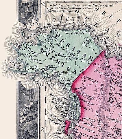
In this 1860 map, Russian America (Alaska) was to the west of British America (Canada). Excerpt from the "Map of North America. Showing its Political Divisions, and Recent Discoveries in the Polar Regions" in Mitchell's New General Atlas, Containing Maps Of The Various Countries Of The World, Plans Of Cities, Etc. Published By S. Augustus Mitchell, Jr. No. 31 South Sixth Street. 1860. |
| Date | 2006-08-15 (original upload date) |
| Source | Originally from en.wikipedia; description page is/was here. |
| Author | Original uploader was Flux.books at en.wikipedia |
| Permission ( Reusing this file) |
PD-US. |
Licensing
 |
This media file is in the public domain in the United States. This applies to U.S. works where the copyright has expired, often because its first publication occurred prior to January 1, 1923. See this page for further explanation. |
|
|
|
This image might not be in the public domain outside of the United States; this especially applies in the countries and areas that do not apply the rule of the shorter term for US works, such as Canada, Mainland China (not Hong Kong or Macao), Germany, Mexico, and Switzerland. The creator and year of publication are essential information and must be provided. See Wikipedia:Public domain and Wikipedia:Copyrights for more details. |
File usage
The following pages on Schools Wikipedia link to this image (list may be incomplete):
Did you know...?
Schools Wikipedia was created by children's charity SOS Children's Villages. SOS Children helps those who have nothing and no one, giving them back the famly they have lost and bringing them the very best opportunities for a happy, healthy future. There are many ways to help with SOS Children.