
File:Mapa administrativa Bogota.png
Mapa_administrativa_Bogota.png (600 × 279 pixels, file size: 48 KB, MIME type: image/png)
| |
This is a file from the Wikimedia Commons. Information from its description page there is shown below.
Commons is a freely licensed media file repository. You can help. |
Summary
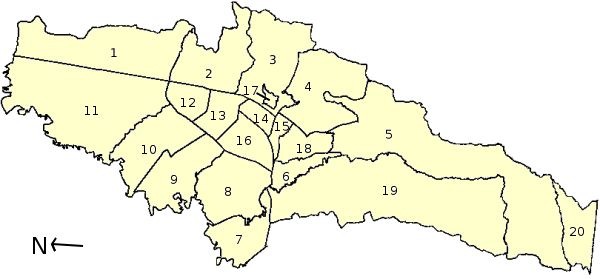
| Description | Administrative Gliederung von Bogotá, Kolumbien / Municipalities of Bogotá, Colombia / Localidades de Bogotá, Colombia. 1 - Usaquén, 2 - Chapinero, 3 - Santafé, 4- San Cristóbal, 5 - Usme, 6 - Tunjuelito, 7 - Bosa, 8 - Kennedy, 9 - Fontibón, 10 - Engativá, 11 - Suba, 12 - Barrios Unidos, 13 - Teusaquillo, 14 - Los Mártires, 15 - Antonio Nariño, 16 - Puente Aranda, 17 - La Candelaria, 18 - Rafael Uribe, 19 - Ciudad Bolívar, 20 - Sumapaz |
| Date | 24 May 2006 |
| Source | Own work |
| Author | Louise Wolff ( darina) |
Licensing
 |
I, the copyright holder of this work, release this work into the public domain. This applies worldwide. In some countries this may not be legally possible; if so: I grant anyone the right to use this work for any purpose, without any conditions, unless such conditions are required by law.
|
File usage
The following pages on Schools Wikipedia link to this image (list may be incomplete):
Wikipedia for Schools...
Schools Wikipedia was created by children's charity SOS Children. SOS Children's Villages is an international children's charity, providing a good home and loving family to thousands of children who have lost their parents. We also work with communities to help vulnerable families stay together and raise children in the best possible environment. Will you help another child today?