
File:Falkland Islands topographic map-en.svg
| |
This is a file from the Wikimedia Commons. Information from its description page there is shown below.
Commons is a freely licensed media file repository. You can help. |
| |
This is a featured picture, which means that members of the community have identified it as one of the finest images on the English Wikipedia, adding significantly to its accompanying article. If you have a different image of similar quality, be sure to upload it using the proper free license tag, add it to a relevant article, and nominate it. |
 |
This SVG image contains embedded raster graphics. Such images are liable to produce inferior results when scaled to different sizes. If appropriate to do so, they should be replaced with images created using vector graphics. |
|
 |
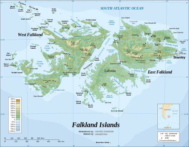
This image was selected as picture of the day on Wikimedia Commons for 24 April 2009. It was captioned as follows: English: The Falkland Islands are an archipelago in the South Atlantic Ocean, located 300 miles off the coast of Argentina. They consist of two main islands, East Falkland and West Falkland, together with about 700 smaller islands. Stanley, on East Falkland, is the capital and largest city. The islands are a self-governing Overseas Territory of the United Kingdom.
Bosanski: Foklandska ostrva su arhipelag u južnom Atlantiku, smješten 300 milja od obale Argentine. Sastoji se od dva glavna ostrva, Istočni fokland i Zapadni fokland, i oko 700 manjih ostrva. Stanley, na Istočnom Foklandu, je glavni i najveći grad. Ostrva su samouprvna Prekomorska teritorija Ujedinjenog Kraljevstva.
Česky: Topografická mapa Falkland, souostroví v jižním Atlantiku
Dansk: Topografisk kort over Falklandsøerne i Sydatlanten i engelsk version. Dansk version her.
Deutsch: Topographische Karte der Falklandinseln im südlichen Atlantik, englische Version; deutsche Version hier
English: The Falkland Islands are an archipelago in the South Atlantic Ocean, located 300 miles off the coast of Argentina. They consist of two main islands, East Falkland and West Falkland, together with about 700 smaller islands. Stanley, on East Falkland, is the capital and largest city. The islands are a self-governing Overseas Territory of the United Kingdom.
Español: Las Islas Malvinas son un archipiélago del Océano Atlántico sur, ubicado a 300 millas de las costas de Argentina. Las islas más grandes son Soledad y Gran Malvina, también la componen otras 700 pequeñas islas. Puerto Stanley, en la Isla Soledad, es la capital y ciudad más poblada de las islas.
Suomi: Topografinen kartta Falklandinsaarista.
Français : Carte topographique en anglais des Îles Malouines. Les Malouines forment un archipel dans l'Océan Atlantique Sud à 480 km des côtes argentines. Il est composé de deux îles principales, East Falkland et West Falkland, et de 700 autres îles et îlots. Stanley, sur East Falkland, est la capitale et la plus grande agglomération de l'archipel. Les Malouines sont un territoire d'outre-mer du Royaume-Uni.
עברית: איי פוקלנד הם ארכיפלג של כ-200 איים בדרום האוקיינוס האטלנטי המהווים טריטוריה בעלת שלטון עצמי של הממלכה המאוחדת.
Magyar: A brit tengerentúli területek közé tartozó Falkland-szigetek topográfiai térképe
Italiano: Mappa geografica delle isole Falkland, territorio d'oltremare del Regno Unito.
Македонски: Фолкландските Острови се архипелаг Јужниот Атлантски Океан, околу 480 km од крајбрежјето на Аргентина. Архипелагот се состои од два главни острова - Источен Фолкланд и Западен Фолкланд, како и 700 помали острови. Главен и најголем град е Стенли, кој се наоѓа на островот Источен Фолкланд. Фолкландските Острови уживаат самоуправа како прекуморска територија на Обединетото Кралство.
Nederlands: Topografische kaart van de Falklandeilanden (Engelse versie; Nederlandse versie hier), een Brits overzees gebiedsdeel in de Zuidelijke Atlantische Oceaan. De archipel bestaat uit twee hoofdeilanden en ongeveer 700 kleinere op ongeveer 300 kilometer uit de kust van Argentinië. Dit land claimt de eilandengroep en poogde in 1982 tevergeefs om het gebied op de Britten te veroveren tijdens de Falklandoorlog.
Polski: Mapa topograficzna Falklandów. Wersja polska dostępna tutaj.
Português: Mapa topográfico (em inglês) das Ilhas Malvinas, um arquipélago no sul do Oceano Atlântico, a 300 milhas da costa da Argentina. Consiste de duas ilhas, Soledad a leste e Gran Malvina, a oeste, junto com cerca de 700 outras ilhotas. A capital (e maior cidade) é Stanley. As Malvinas são um território autónomo do Reino Unido.
Română: Insulele Falkland compun un arhipelag în sudul Oceanului Atlantic, aflat la 300 de mile de coastele Argentinei. Arhipelagul este compus din două insule principale, Falkland de Est şi Falkland de Vest, împreună cu alte 700 de insule mai mici. Oraşul Stanley, de pe Insula Falkland de Est, este capitala şi cel mai mare oraş. Insulele sunt un teritoriu de peste mări al Regatului Unit.
Русский: Топографическая карта Фолклендских островов
Українська: Детальна топографічна карта Фолклендських островів
中文(简体): 福克兰群岛是一个位于大西洋的群岛,距离阿根廷海岸300英里。主要分为东福克兰群岛和西福克兰群岛,总计有700多座小岛。 斯坦利港为其首都和最大的城市。
中文(繁體): 福克蘭群島地形圖
|
![]()
Detailed map of large dimension. For a better viewing, click on the link of the image above.
Carte détaillée de grande dimension. Pour une visualisation optimale, cliquer sur le lien de l'image ci-dessus.
Summary
| Description |
English: The Falkland Islands are an archipelago in the South Atlantic Ocean, located 300 miles off the coast of Argentina. They consist of two main islands, East Falkland and West Falkland, together with about 700 smaller islands. Stanley, on East Falkland, is the capital and largest city. The islands are a self-governing Overseas Territory of the United Kingdom.
Français : Carte topographique en anglais des Îles Malouines. Les Malouines forment un archipel dans l'Océan Atlantique Sud à 480 km des côtes argentines. Il est composé de deux îles principales, East Falkland et West Falkland, et de 700 autres îles et îlots. Stanley, sur East Falkland, est la capitale et la plus grande agglomération de l'archipel. Les Malouines sont un territoire autonome du Royaume-Uni.
Nederlands: Topografische kaart van de Falklandeilanden, een Brits overzees gebiedsdeel in de Zuidelijke Atlantische Oceaan. De archipel bestaat uit twee hoofdeilanden en ongeveer 700 kleinere op ongeveer 300 kilometer uit de kust van Argentinië. Stanley op het eiland 'East Falkland' is de hoofdstad en tergelijkertijd de meest bevolkte gemeente van het eilandengroep.De eilanden zijn een 'self-governing Overseas Territory' van het Verenigd Koninkrijk van Groot-Brittannië en Noord-Ierland.
Português: Mapa topográfico (em inglês) das Ilhas Malvinas, um arquipélago no sul do Oceano Atlântico, a 300 milhas da costa da Argentina. Consiste de duas ilhas, Soledad a leste e Gran Malvina, a oeste, junto com cerca de 700 outras ilhotas. A capital (e maior cidade) é Stanley. As Malvinas são um território autónomo do Reino Unido.
|
||
| Date | November 2007 using elements from the original version of April 2007 | ||
| Source | Own work ; Topographic map : NASA Shuttle Radar Topography Mission (SRTM3 v.2) (public domain) edited with dlgv32 Pro/Global Mapper and vectorized with Inkscape ; UTM projection ; WGS84 datum ; shaded relief (composite image of N-W, W and N lightning positions) ; Approximate scale of topographic data and shore / lakes limits : 1:705,000 ; of the bathymetry : 1:3.720.000 Bathymetry : USGov public domain data provided by the Demis add-on for World Wind (see the approval e-mail) ; Other references used for additional data : * UK government map ; * NASA World Wind ; * CIA map available on the site of the University of Texas at Austin ; * Microsoft Encarta atlas (1999 edition). Note : The shaded relief is a raster image embedded in the SVG file which increases its size. If you want a lighter map for other purposes, delete the shaded relief image in your file. |
||
| Author | Eric Gaba ( Sting - fr:Sting) | ||
| Permission ( Reusing this file) |
|
| |
This SVG file uses embedded text that can be easily translated into your language using this automated tool. Learn more. You can also download it and translate it manually using a text editor.
|
Licensing
|

File usage
Metadata
Want to know more?
SOS Children's Villages aims to make Wikipedia suitable for young learners. SOS Children's Villages cares for children who have lost their parents. Our Children's Villages give these children a new home and a new family, while a high-quality education and the best of medical care ensures they will grow up with all they need to succeed in adult life. Have you thought about sponsoring a child?