
File:RegioniIrredenteItalia.jpg
Size of this preview: 368 × 480 pixels.
| |
This is a file from the Wikimedia Commons. Information from its description page there is shown below.
Commons is a freely licensed media file repository. You can help. |
Summary
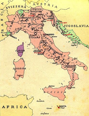
| Description | Map of Kingdom of Italy (1919) showing the areas claimed by Irredentism:in red Malta, in purple Corsica, in yellow with green points Dalmatia, Ticino and Nizzardo. I have used as a basic map an old map from an Italian geography & history school-book of 1935 "Scuole Medie Inferiori", and I have written and painted on it. Cropped caption: L’ Italia dopo la Guerra 1915-1918 |
| Date | April 2008 |
| Source | Own work |
| Author | Brunodambrosio |
Licensing
 |
I, the copyright holder of this work, release this work into the public domain. This applies worldwide. In some countries this may not be legally possible; if so: I grant anyone the right to use this work for any purpose, without any conditions, unless such conditions are required by law.
|
File usage
The following pages on Schools Wikipedia link to this image (list may be incomplete):
Background information
Wikipedia for Schools is one of SOS Children's Villages' many educational projects. More than 2 million people benefit from the global charity work of SOS Children, and our work in 133 countries around the world is vital to ensuring a better future for vulnerable children. Have you heard about child sponsorship? Visit our web site to find out.