
File:Dalriada.jpg
Size of this preview: 460 × 480 pixels.
| |
This is a file from the Wikimedia Commons. Information from its description page there is shown below.
Commons is a freely licensed media file repository. You can help. |
Summary
| Description |
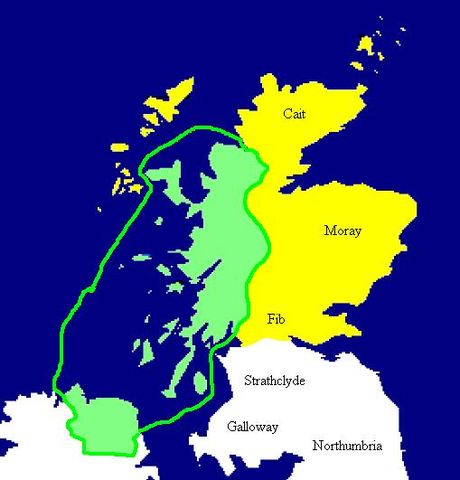
English: Extent of the Kingdom of Dál Riata (in green), c. AD 590. Yellow areas show occupation by the Picts.
Español: Mapa de Dalriada hacia el año 590. Las regiones pictas están marcadas en amarillo.
|
| Date | |
| Source | Copied from en:Image:Dalriada.jpg. |
| Author | en:User:Briangotts |
This image was uploaded in the JPEG format even though it consists of non-photographic data. This information could be stored more efficiently or accurately in the PNG format or SVG format. If possible, please upload a PNG or SVG version of this image without compression artifacts, derived from a non-JPEG source (or with existing artifacts removed). After doing so, please tag the JPEG version with {{ Superseded|NewImage.ext}}, and remove this tag. This tag should not be applied to photographs or scans. For more information, see {{ BadJPEG}}. |
|
 |
This map image could be recreated using vector graphics as an SVG file. This has several advantages; see Commons:Media for cleanup for more information. If an SVG form of this image is already available, please upload it. After uploading an SVG, replace this template with {{ vector version available|new image name.svg}}. |
Licensing
 |
This work has been released into the public domain by its author, Briangotts. This applies worldwide. In some countries this may not be legally possible; if so: Briangotts grants anyone the right to use this work for any purpose, without any conditions, unless such conditions are required by law.
|
File usage
The following pages on Schools Wikipedia link to this image (list may be incomplete):
Schools Wikipedia facts
Wikipedia for Schools is one of SOS Childrens Villages' many educational projects. In 133 nations around the world, SOS Childrens Villages works to bring better education and healthcare to families in desperate need of support. If you'd like to help, why not learn how to sponsor a child?