
File:Pedro De Valdivia Siedlungen in Chile 1540 bis 1553.jpg
Size of this preview: 149 × 478 pixels.
| |
This is a file from the Wikimedia Commons. Information from its description page there is shown below.
Commons is a freely licensed media file repository. You can help. |
| Description |
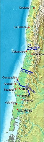
Deutsch: Karte von Chile. Pedro de Valdivia. Koloniale Siedlungen in Chile, 1540 - 1553
English: Map of Chile. Pedro de Valdivia. Locations of colonization in Chile, 1540 - 1553
Español: Mapa de Chile. Pedro de Valdivia. Fundaciones en Chile, 1540 - 1553
|
| Date | 2008-07-20 18:11 (UTC) |
| Source |
|
| Author |
|
| This is a retouched picture, which means that it has been digitally altered from its original version. Modifications: Orte eingezeichnet/locations added. The original can be viewed here: Map_of_Chile_Demis.png. Modifications made by WeHaKa.
|
|

File usage
The following pages on Schools Wikipedia link to this image (list may be incomplete):
What is Schools Wikipedia?
Wikipedia for Schools was collected by SOS Children's Villages. The world's largest orphan charity, SOS Children brings a better life to more than 2 million people in 133 countries around the globe. Have you heard about child sponsorship? Visit our web site to find out.