
File:PanAmericanHwy.png
| |
This is a file from the Wikimedia Commons. Information from its description page there is shown below.
Commons is a freely licensed media file repository. You can help. |
Summary
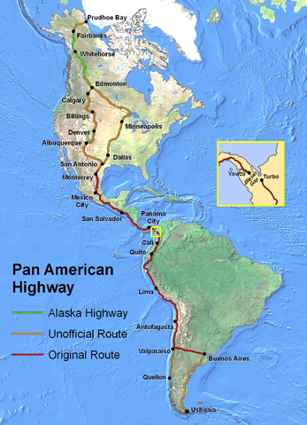
Original Description: Route of the Pan American Highway. Includes original route and unofficial extensions. Hotine Oblique Mercator Two Point Natural Origin Projection.
Taken from en:Image:PanAmericanHwy.png. Created by en:User:Seaweege and released to PD.
 |
This map image could be recreated using vector graphics as an SVG file. This has several advantages; see Commons:Media for cleanup for more information. If an SVG form of this image is already available, please upload it. After uploading an SVG, replace this template with {{ vector version available|new image name.svg}}. |
Licensing
 |
The copyright holder of this work allows anyone to use it for any purpose including unrestricted redistribution, commercial use, and modification.
Usage notes: |
File usage
Learn more
You can learn about nearly 6,000 different topics on Schools Wikipedia. SOS Children helps more than 2 million people across 133 countries around the world. There are many ways to help with SOS Childrens Villages.